 GOVERNMENT OF INDIA
An Analysis of the SVAMITVA Scheme: Successes and Way Forward
In India, the survey of rural land for settlement and record was undertaken and completed decades back and moreover, Abadi area of the villages were not surveyed/mapped in most states. Abadi area is the inhabited land/areas adjoining the wadis/basties. Such an area is usually marked by red line in the revenue maps of the villages and is usually referred to as lal dora in most states. Due to the lack of legal proof/document to support one’s right, the owner of the property in such rural habitations could not leverage their own property as a financial asset acceptable by the banks for the purpose of providing loans and other financial assistance[1]. In order to provide the legal right of the property to the household owner in a time-transparent and cost-effective manner, Government of India launched Survey of Villages Abadi and Mapping with Improvised Technology in Village Areas (SVAMITVA) Scheme. The pilot phase of the scheme was implemented in 2020-21 in Haryana, Karnataka, Madhya Pradesh, Maharashtra, Uttar Pradesh, Uttarakhand, Punjab, Rajasthan and Andhra Pradesh, followed by a nationwide roll-out of the scheme in April 2021. SVAMITVA scheme is a collaborative effort of the Ministry of Panchayati Raj (MoPR), State Panchayati Raj Departments, State Revenue Departments and Survey of India (SOI).
The major objective of the scheme is to bring financial stability to the citizens in rural India by enabling them to use their property as a financial asset for taking loans and other financial benefits. The scheme also aims for creating accurate land records, reducing property disputes, accurate determination of property tax in Gram Panchayats (GPs), and preparation of better-quality Gram Panchayat Development Plans by making use of GIS maps.
Before initiating drone mapping, Operating Reference Systems (CORS) are established. This geo-positioning infrastructure allows accurate mapping through drone technology and thus replaces the chain surveys practised in several states. The CORS once established can be used by any state agency/department for surveys and GIS-based applications.
So, how does this scheme work?… The implementation of the scheme starts with identifying and notifying villages within districts for drone mapping. Villagers are then sensitised with the help of the Revenue Department and GP officials about the scheme, its benefits and activities. The Abadi areas are demarcated using chuna (limestone powder) lines followed by the drone survey and creation of maps (data processing, feature extraction). Subsequently, round verification, correction of maps, and inquiry processes are undertaken by the state revenue department and GP officials. The final map and property data are generated followed by the creation and distribution of property cards by the state’s revenue department. As per the scheme guidelines, many steps involved in the implementation of the scheme are mentioned as the combined responsibility of more than one stakeholder, with a significant role played by state departments.
So far, the budget allocated for SVAMITVA scheme is ₹ 79.65 Cr. (Actual), ₹ 140 Cr. (RE) & ₹ 150 Cr. (BE) for the fiscal year 2020-21, 2021-2022, and 2022-23 respectively[2]. This might subsequently decrease in the coming years as the capital-intensive activity of establishing the CORS would be completed in the initial years.
Every scheme/programme is monitored on the basis of Key Performance Indicators (KPIs) specifically designed for the scheme/programme.
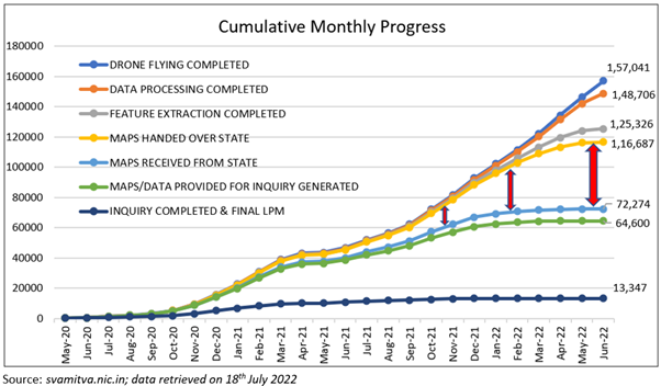
The above chart shows the cumulative monthly progress across various KPIs of SVAMITVA. There is a progressively increasing gap between the ‘handing over of the maps to the states’ and the ‘receiving of the maps from states’ for changes. As mentioned earlier drone flying, data processing, feature extraction, and handing over maps to states is done by SOI while further activities require significant support from the State Revenue Department and Gram Panchayat.
As mentioned in the table below, drone flying has been completed in 1,62,117 villages, around 57 % of currently notified villages and 28% of total villages. A significant number of villages have been surveyed in Haryana, Uttar Pradesh, Madhya Pradesh, Uttarakhand and Goa. The number of notified villages in states would increase subsequently as the scheme progresses.
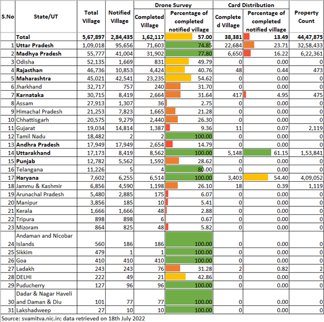
Drone flying is the first major activity conducted in the village as a part of the scheme by SOI. So far 2,84,435 villages have been notified across 410 districts in India for the implementation of the scheme. The figure below shows the spatial mapping of the percentages of the villages completed (drone flying) across districts. Out of the total of 410 districts with notified villages, about 72 have been fully covered with the maximum being from Haryana (21), Uttarakhand (13) and a number of districts have been surveyed in Uttar Pradesh and Madhya Pradesh. The percentage coverage of districts will vary as more villages are notified till saturation is achieved.

The above temperature map has been constructed using tableau software. Many recently created/declared new districts across different states might not be visible due to the unavailability of the latest shape file (including the 13 new districts of Andhra Pradesh)
One of the major outcomes of the scheme includes updating the ‘record-of-rights’ in the revenue/property registers and issuance of property cards to the property owners. This facilitates the monetization of rural residential assets for credit and other financial services. Further, this would also pave the way for clear determination of property tax, which would accrue to the GPs leading where devolved[3]. Till 18th July 2022, around 45 lakh property cards have been distributed across 38,381 villages of Uttar Pradesh, Madhya Pradesh, Uttarakhand, Haryana, Karnataka, Rajasthan, Jammu & Kashmir, Gujarat and Ladakh.
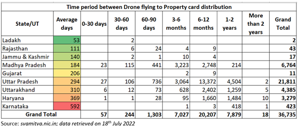
The table below shows the time gap analysis for 36,735 villages where property cards have been distributed. The average number of days between the drone flying and card distribution was about 53 days for Ladakh and 111 days for Rajasthan, followed by 140 for J&K and 184 for Madhya Pradesh. The good practices followed by Ladakh and Rajasthan can be documented and replicated by other states for timely implementation of the scheme. Madhya Pradesh was able to complete the property card distribution in a time-bound manner because it has specified a time limit. As per Rule 26 of Madhya Pradesh Bhu-Rajasva Samhita Rules 2020, the work of distribution of property Cards must be completed within 8 months from the date of proclamation of the survey, except under extraordinary circumstances[3].
In order to further enhance the reach and impact of the scheme, the following suggestions may be considered:
● Legal experts could be made a part of the State Programme Management Unit for examining the revenue-related laws to answer the question of authority to issue the property card and its validity. The legal expert may be tasked with drafting the required amendments to the existing laws[4].
● State Governments could consider coordinating with the State Level Bankers Committee (SLBC) for providing recognition to property cards generated under the scheme. The property card format could be finalized by the states in engagement with banks[3].
● States may be incentivized on the outcome i.e, the creation and distribution of property cards for improving the outcome achievement.
● An Output and Outcome Monitoring Framework for the scheme could be created with due importance given to the final outcome of providing property rights i.e., distribution of property cards.
● An accessible grievance redressal mechanism may be put in place in every state, where one does not already exist, starting with proper escalation matrix (GP, Tehsil District, State) for timely resolution of disputes.
Through effective implementation, this scheme has the potential to be a game changer, directly impacting the economic health of rural households and also supporting strategic planning through GIS-based maps for the development of villages.
Disclaimer: Views expressed are personal.
[1] Government of India. Framework For Implementation of SVAMITVA guidelines (2021-2025). New Delhi: Ministry of Panchayati Raj
https://svamitva.nic.in/DownloadPDF/SvamitvaGuidelinesupdated_1644233812678.pdf
[2] Government of India. (2022). Notes on Demand for Grants, 2022-2023 (Demand no. 72). New Delhi: Ministry of Finance
https://www.indiabudget.gov.in/doc/eb/sbe72.pdf
[3] Government of India. (2021). Concept Note: A Stepping-Stone towards upliftment of Rural Economy. New Delhi: Ministry of Panchayati Raj
https://svamitva.nic.in/DownloadPDF/ConceptNoteSVAMITVASCHEME_1645772572793.pdf
[4] Property, Rights Research Consortium. (2020). SVAMITVA: Inputs towards design of the next phase of the scheme.
https://svamitva.nic.in/DownloadPDF/PRRCStudyReport_1634724050493.pdf